Trail Walking Le Poët-Sigillat - poët Sigillat-col de Soubeyrand-Tarendol - Photo

poët Sigillat-col de Soubeyrand-Tarendol

© OpenStreetMap contributors
Length
Length
12.9 km
Max alt
Max alt
1158 m
Uphill gradient
Uphill gradient
567 m
Km-Effort
Km-Effort  
20 km
Min alt
Min alt
659 m
Downhill gradient
Downhill gradient
571 m
Boucle
Boucle
Yes
Creation date :
2021-07-17 06:49:39.879
Updated on :
2021-07-24 15:49:29.883

(0 Reviews)

Walking
Walking
3h35
Difficulty : Medium

Scan this QR Code to open this trail in the SityTrail application

FREE GPS app for hiking

Logo SityTrail SityTrail

IGN / Geographical institutes

Download SityTrail from the App Store Download SityTrail from Google Play

Logo SityTrail SityTrail World

The world is yours!

Download SityTrail from the App Store Download SityTrail from Google Play Download SityTrail on Huawei AppGallery

About

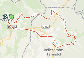
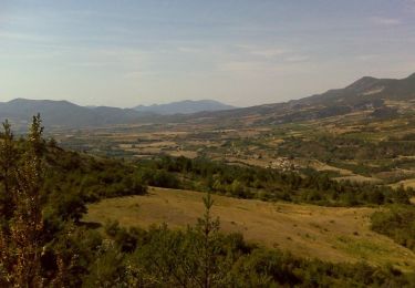
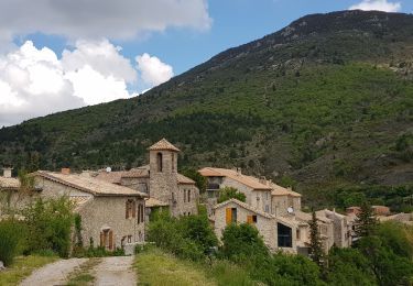
Trail Walking of 12.9 km to be discovered at Auvergne-Rhône-Alpes, Drôme, Le Poët-Sigillat. This trail is proposed by Bruno Berlemont .
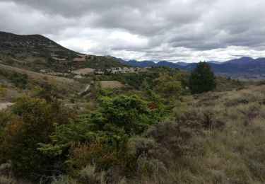
Description

superbe balade !
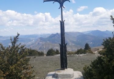
points de vue magnifiques sur tout le parcours.
petite visite sur la tombe de René Barjavel à Tarendol.
Le parcours est en montée (500 m D ) les 2 premiers kms.
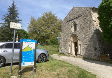
point de départ : Parking du cimetière du Poët Sigillat

Elevation profile

Photos

Positioning

Country:
France
Region :
Auvergne-Rhône-Alpes
Department/Province :
Drôme
Municipality :
Le Poët-Sigillat
Location:
Unknown
Start:(UTM)
684748 ; 4915331 (31T) N.

Trails nearby

Trail Road bike Sainte-Jalle - Col d’Ey depuis Sainte Jalle via Rochebrune  - Photo
Road bike
Pierre Jongen

Road bike

Medium
Sainte-Jalle, Auvergne-Rhône-Alpes, Drôme, France
18.8 km | 24 km-effort
1h 55min
Yes
Trail Walking Arpavon - BruBer-Arpavon : ND Consolation - Photo
Walking
Bruno Berlemont

Walking

Medium
Arpavon, Auvergne-Rhône-Alpes, Drôme, France
5.5 km | 8.2 km-effort
1h 30min
Yes
Trail Walking Sainte-Jalle - GRP Baronnies Ste Jalle Arpavon 18km - Photo
Walking
GUIDE
thonyc

Walking

Medium
Sainte-Jalle, Auvergne-Rhône-Alpes, Drôme, France
18 km | 27 km-effort
5h 32min
Yes
Trail Walking Bésignan - Autour du rocher des Mieyes - Besignan - Photo
Walking
tracegps

Walking

Medium
Bésignan, Auvergne-Rhône-Alpes, Drôme, France
17.2 km | 26 km-effort
5h 30min
Yes
Trail Mountain bike Le Poët-Sigillat - La Grande Javonière - Photo
Mountain bike
tracegps

Mountain bike

Difficult
Le Poët-Sigillat, Auvergne-Rhône-Alpes, Drôme, France
13.9 km | 20 km-effort
2h 0min
Yes
Trail Walking Le Poët-Sigillat - La Grande Javonière - Photo
Walking
tracegps

Walking

Medium
(1)
Le Poët-Sigillat, Auvergne-Rhône-Alpes, Drôme, France
13.9 km | 20 km-effort
4h 30min
Yes
Trail Walking Sainte-Jalle - Sainte jalle - Photo
Walking
Vero7684

Walking

Medium
Sainte-Jalle, Auvergne-Rhône-Alpes, Drôme, France
10.5 km | 18.1 km-effort
3h 53min
Yes
Trail Electric bike Saint-Sauveur-Gouvernet - 26 - col de Soubeyrand par St Sauveur G. et le Poet Sigillat - Photo
Electric bike
chris13370

Electric bike

Medium
Saint-Sauveur-Gouvernet, Auvergne-Rhône-Alpes, Drôme, France
24 km | 32 km-effort
1h 50min
Yes
Trail Walking Montréal-les-Sources - Montréal Les sources  - Photo
Walking
Vero7684

Walking

Medium
Montréal-les-Sources, Auvergne-Rhône-Alpes, Drôme, France
14.8 km | 25 km-effort
4h 58min
Yes


Close
My subscriptions